Online map of military actions in Ukraine on November 2: situation at the front.
02.11.2024
3296

Journalist
Shostal Oleksandr
02.11.2024
3296
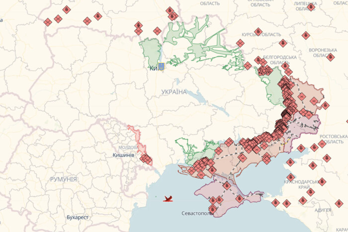
The "Glavcom" site decided to collect online maps of military actions in Ukraine to better understand the situation at the front and track the liberation of our lands.
Deep State Map of military actions
Symbols on the Deep State map:
- blue: territory liberated in the last two weeks
- green: liberated territory
- gray: territory requiring clarification
- red: territory occupied by Russians
- dark red: territory of Crimea and ORDLO
- light red: occupied territories of other states
The map also marks railways, units, headquarters, airfields, and enemy directions of attack.
Liveuamap of military actions
Symbols on the Liveuamap:
- red: territory occupied by Russians
- blue: territory freed from Russians
The map marks important military objects of the enemies and events of military and political nature.
ISW (Institute for the Study of War) map of military actions
ISW (Institute for the Study of War) constantly updates its map of military actions to analyze the course of the Russian-Ukrainian war.
Symbols on the ISW map:
- black: occupied Crimea and ORDLO
- red: occupied territories during the full-scale war
- red dashed: lands captured by occupiers in the last 24 hours
- blue dashed: lands liberated by Ukraine in the last 24 hours
- light blue dashed: Ukraine's statements about counteroffensive and resistance
Dear citizens!
A full-scale war is currently ongoing in Ukraine, and we must follow official sources, avoid unreliable data, and support our army. Together we will defeat the enemy!
Glory to Ukraine!
Read also
- Attack on Zaporizhzhia: Photos of the Consequences Have Emerged
- Russia attacked Ukraine at night with 157 drones: hits in 19 locations
- Map of military actions in Ukraine as of July 6, 2025
- Pokrovsk: ISW analysts have predicted the plans of the occupiers
- Enemy losses as of July 6, 2025 – Armed Forces of Ukraine Headquarters
- In Kyiv region, there are injuries and destruction due to drone attacks

